
 |
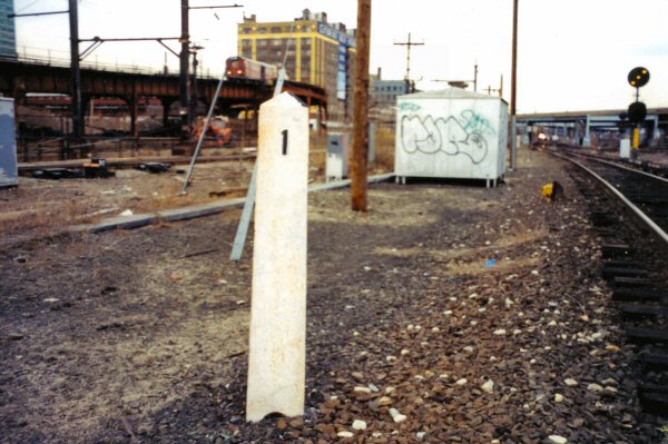
| MP 1 on the Mainline, just east of Hunterspoint Avenue (Photo credit: Dave Keller/Trains Are Fun.com) |
The first milepost is placed at "chaining 0"
and then there is [usually] a mile post every 5,280 feet.
 |
| Montauk Branch MP 26, as seen from the Wantagh station platform (Photo credit: The LIRR Today) |
And the railroad's "chaining 0" are pretty interesting. Usually, mileposts are marked from the city-out. So on the LIRR "chaining 0" will be on the west side of the island and the mileposts are numbered going east. On the opposite hand, NJTransit has their mileposts measured going west, since their flipped being on the other side of Manhattan.
 |
| MP 104 on the Montauk Branch near AG Siding in Amagansett (Photo credit: Trains Are Fun.com) |
But they would be incorrect. The LIRR actually has three different "chaining 0"'s. The three different MP 0.0's are located at Long Island City, Atlantic Terminal, and Valley Stream. All of the LIRR's branches measure their mileposts in relation to their distance from one of these three places.
However, if you read the "LIRR's 11 Branches" post and you know that the Port Jefferson Branch starts at Hicksville and doesn't really exist west of there, you might think Hicksville would be a "chaining 0" for the Port Jefferson Branch. But that's not correct either. For most of the LIRR's branches, their mileposts are just continued from the line from which they split.
Mineola is technically at MP 18.5. The Oyster Bay Branch splits off just east of Mineola. Does that make East Williston at MP 1.3 since it's 1.3 miles up the Oyster Bay Branch? Since Mineola is not one of the three "chaining 0"'s on the railroad, the mileposts on the Oyster Bay Branch are just continued off the mainline. So East Williston is really at milepost 19.8.
The same thing works with the Port Washington, Port Jefferson, Hempstead and Central branches. Their mileposts are just continued off the Mainline. All of these branches (including the Oyster Bay branch as used in the example above) have their mileposts measured from Long Island City.
It works slightly differently for the Far Rockaway, Long Beach, and West Hempstead Branches. Like we said in yesterday's VALLEY Interlocking Walkthrough, these three branches officially begin at Valley Stream. But since Valley Stream is one of the three "chaining 0"'s on the railroad, these branches have their mileposts measured from Valley Stream, not Long Island City or Brooklyn.
The Atlantic Branch, which originates at Brooklyn and not Long Island City, instead has its mileposts measured from there.
So to tie this all together, here's a table with all of the branches, where all their mileposts are measured from, and what the easternmost milepost on the branch is:
Branch
|
“Chaining 0”
|
Easternmost Point
|
Mainline
|
Long Island City (via Main)
|
Greenport Yard (MP 94.3)
|
Montauk Branch
|
Long Island City (via Mtk)
|
Montauk Yard (MP 115.8)
|
Atlantic Branch
|
Atlantic Terminal
|
Valley Stream (MP 15.8)
|
Port Washington Branch
|
Long Island City (via Main)
|
Port Washington (MP 18.1)
|
Hempstead Branch
|
Long Island City (via Main)
|
Hempstead (MP 19.8)
|
Oyster Bay Branch
|
Long Island City (via Main)
|
Oyster Bay Yard (MP 33.2)
|
Port Jefferson Branch
|
Long Island City (via Main)
|
Port Jefferson E. Yd (MP 58.2)
|
Central Branch
|
Long Island City (via Main)
|
BABYLON Int. (MP 35.8)
|
Far Rockaway Branch
|
Valley Stream
|
Far Rockaway (MP 5.0)
|
Long Beach Branch
|
Valley Stream
|
Long Beach (MP 6.9)
|
West Hempstead Branch
|
Valley Stream
|
West Hempstead (MP 4.6)
|
Comparing Mileposts is an excellent way to compare the location of different places on the railroad. Even though Mileposts are measured from three different points on the railroad, they are all more or less the same when everything shakes out. Even though there are two different routes to get from Long Island City (via the Mainline or via the Lower Montauk), two different ways to get from Jamaica to Valley Stream (via the Atlantic Branch or the Montauk Branch), and two different ways to get from Jamaica to Babylon (via the Montauk Branch or the Mainline/Central Branch) everything is pretty much the same.
There may be different physical characteristics that make traveling over one route faster than the other, but from a distance point of view, there is a lot of equality on the railroad. Take a look at the following diagrams I whipped up quickly in Photoshop (I was trying to draw the lines for the text while on the train, so they might be a bit sloppy, so forgive me) that show the distances between two points via different routings:


 |
| MP 31 on the Central Branch. (Photo credit: Trains Are Fun.com) |
Like in the instances above, the Mainline would be faster between Long Island City and Jamaica because the Lower Montauk (which isn't really LIRR territory anymore) has a much lower speed limit. In a similar way, the Atlantic Branch is slightly faster between Jamaica and Valley Stream. Not only is it 0.4 miles shorter, ducking right out of HALL interlocking is much quicker than the crawl that trains destined for the Montauk Branch usually have to take east of Jamaica. But between Jamaica and Babylon the Montauk Branch wins out. Not only is the Mainline/Central combination 0.8 miles longer, the Montauk Branch has a MAS of 80 m.p.h. for huge chunks of the run. The Mainline has a 40 m.p.h. hangup at DIVIDE interlocking and the Central Branch's MAS is a lower 65 m.p.h.
But in most cases, if a train is routed via a different routing than the scheduled one, the distances and conditions are not all that different, so the schedule wouldn't really be impacted. In each case one option is faster than the other, but only by a couple minutes in most cases when push comes to shove.
In conclusion, Mileposts are interesting things. They serve a very useful purpose as they give a meaningful location to everything on the railroad. It's a very simple system that dates back to the dawn of railroading. No complex GPS systems or satellite receivers giving latitude and longitude coordinates that nobody understands, just chunks of painted wood shoved in the ground. Couldn't be much simpler.
For more photos of different LIRR mileposts, check out Steve Lynch's Trains Are Fun.com page on LIRR Mileposts.

Excellent post! Oddly enough, I recall reading somewhere that MP 0.0 was actually on the East River waterfront some distance west of the current end of track at LIC, so it doesn't really exist anymore. (Maybe this explains why the ride between LIC and HPA has never seemed like a full mile to me!) There are supposed to be a lot of other discrepancies here and there on the system, the result of various deviations and realignments and grade crossing eliminations over the years (I believe the concrete mileposts were set in the early 1900s, and a lot's changed since then), so the distances they indicate are often merely approximations.
ReplyDeleteYes, there are quite a few discrepancies in regards to mileposts on the LIRR, far to many to go through here. But you are on the right track, the "original" MP 0 was at the old Long Island City terminal on the waterfront. When the current station and yard were constructed, MP 0 was "technically" relocated to there, but changing practically every other milepost on the LIRR (since all but a handful of branches had their MP's measured from that spot) proved to not really be worth it, so the real distance between MP 0 and MP 1 is really only like 0.7 miles because of this.
DeleteBut such are the difficulties that arise when you're dealing with a 181-year old railroad that has undergone so many changes!
~ Patrick @ The LIRR Today
Is that what those markers represent?! There's one of them just off to the side of the Eastbound platform at Douglaston Station (about 1-2 car-lengths west of the east end of the platform - I think it says "12"). I always wondered what it was. Now I know :) Thanks!
ReplyDeleteSouth Shore verses Main Line for a Montauk Branch diesel train saves 0.8 to 1.2 miles and reduces grade-crossing exposure to zero, yet they seldom route trains that way anymore, even when there are no Babylon locals in the way and they can.
ReplyDeleteThat's one thing that's always baffled me, they have the room and it is slightly faster, why not send them down the Babylon? My trains (2703 and 2716) always go via the Mainline/Central. I know 2703 stops at Hicksville and Mineola, but 2716 doesn't, and there's room on the Babylon Branch at that time.
Delete~ Patrick @ The LIRR Today
Some of the weekend trains can to. Threading them between Ronokonkoma, Huntington, and Oyster Bay trains is very difficult.
ReplyDeleteSo two (maybe two-and-a-half) questions relating to this:
ReplyDelete1. What MP does Penn Station represent? Negative-one?
2. Why does the PW branch use LIC as its Chaining 0 if no trains from that branch go there? (*Can* trains from PW even go to HPA/LIC if needed? Do the right switches exist to route a train that way?)
Thanks!
1) Penn Station is not an LIRR station and the tracks leading there are not LIRR tracks, so they are not taken into account when doing LIRR mileposts (after all, for the first couple decades of the LIRR's existence there was no Penn Station, only Long Island City). Penn Station is theoretically at MP negative one (and GCT will be around MP negative 2 or 3) since it is another mile or so past Long Island City.
Delete2) At one point, all Port Washington trains ended up in Long Island City, so when the branch was constructed, all the mileposts were measured from there. Then, when Penn Station opened, more and more trains got shifted over there until today when all of the Port Washington Branch trains make their way into Penn Station. It is possible for Port Washington Branch trains to get over to Hunterspoint Avenue. Back in June when the 6/17 derailment of a Hempstead Branch train outside Penn Station restricted throughput into the station the LIRR diverted one Port Washington Branch train to HPA.